
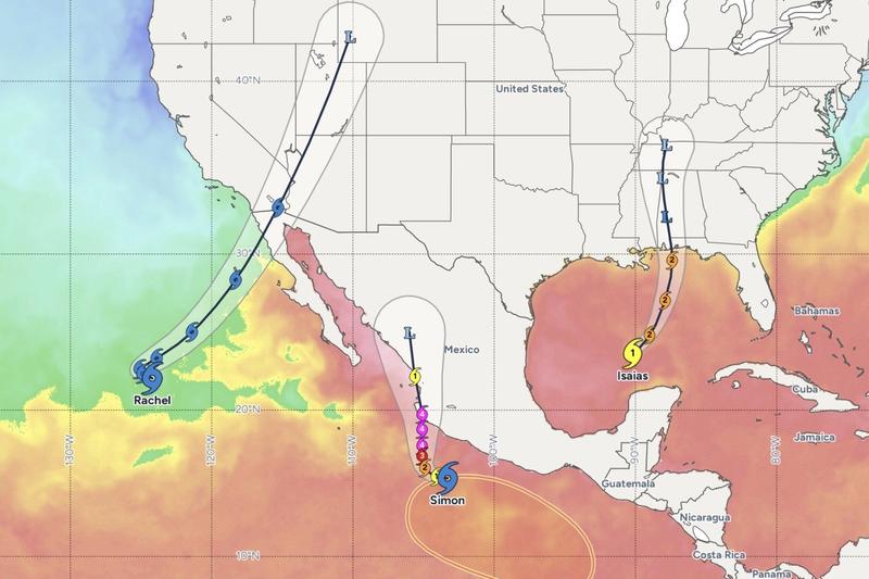
Rachel Strengthens Toward Hurricane Force
Tropical Storm Rachel strengthened toward hurricane intensity on Oct. 8, 2026, as the cyclone tracked toward landfall along the Pacific coast. The National Hurricane Center continued to monitor the system as it organized over warm Eastern Pacific waters. Landfall timing remained tied to the storm’s forward speed and the evolution of its inner core. Coastal communities and a major vacation corridor sat in the potential impact zone as the calendar day unfolded.
The New York Post reported that the storm was strengthening ahead of Pacific coast landfall and that a U.S. triple-threat weather pattern was approaching at the same time. Emergency managers faced a landfalling Pacific cyclone and a separate continental weather threat on the same day. Rachel’s name follows the rotating Eastern North Pacific list maintained under World Meteorological Organization procedures. October remains inside the official Eastern Pacific hurricane season, which runs from May 15 through Nov. 30.
Official Advisories and Verified Reporting
Federal tropical cyclone warnings for the Eastern North Pacific originate with the National Hurricane Center in Miami. The center issues public advisories, forecasts of track and intensity, and tropical storm or hurricane watches and warnings when coastal areas face a threat. Mexico’s national weather service issues complementary alerts for Mexican Pacific states when a cyclone approaches that coastline. Local emergency management offices translate those products into evacuation orders, shelter openings, and marine restrictions.
The New York Post account on Oct. 8 described Rachel as strengthening ahead of landfall and framed a concurrent U.S. triple-threat approach. No independent confirmation of casualties, structural losses, or finalized landfall coordinates was attached to that initial report. The National Hurricane Center remains the primary U.S. source for intensity, track, and watch-and-warning status on Eastern Pacific named storms. Mariners, airlines, and port operators typically act on those advisories as soon as watches are posted, often 48 hours before expected tropical-storm-force winds.
Eastern Pacific Season, Storm Names, and the Coastal Record
The Eastern North Pacific hurricane season begins May 15 and ends Nov. 30 each year. Long-term National Oceanic and Atmospheric Administration records put the basin average at about 15 named storms, eight hurricanes, and four major hurricanes per season. October sits in the latter third of that window. Sea-surface temperatures along the Mexican Pacific and west of Baja California often remain warm enough in early October to support tropical cyclones. Rachel is a name on the predetermined Eastern Pacific rotating lists. Those lists are maintained through the World Meteorological Organization and cycle every six years unless a name is retired after a deadly or costly storm.
Historic Landfalls in Western Mexico
Landfalling Eastern Pacific hurricanes most often strike western Mexico. Baja California Sur, Sinaloa, Nayarit, Jalisco, and Colima have taken direct hits across recent decades. Hurricane Odile in September 2014 made landfall on the Baja Peninsula and caused extensive damage in the Los Cabos tourism corridor, including Cabo San Lucas and San Jose del Cabo. Hurricane Patricia in October 2015 became the strongest hurricane on record in the Eastern Pacific, with maximum sustained winds estimated at 215 miles per hour before a Mexican landfall along a less populated stretch of coast. Those two storms remain the modern reference points for emergency planners from Mazatlan to Puerto Vallarta to Los Cabos.
Pacific Mexico’s vacation economy concentrates hotels, cruise calls, and air traffic in a handful of coastal hubs. Los Cabos International Airport and Puerto Vallarta’s Gustavo Diaz Ordaz International Airport handle heavy seasonal passenger loads. Cruise terminals and small-craft harbors close on official guidance when tropical-storm-force winds are forecast. A storm approaching a vacation hotspot, the phrase used in the Oct. 8 coverage, carries life-safety and economic stakes. Visitors may lack local language fluency. Lodging may be high-rise glass construction. Marine recreation puts people on the water until warnings are heeded.
ByteSize Network previously covered a different basin’s landfall threat during Hurricane Isaias, when Gulf Coast counties declared a state of emergency. The Isaias episode illustrated the same operational sequence now relevant to Rachel: watches, warnings, emergency declarations, and the compression of time as a cyclone nears land. The basins differ. Isaias was an Atlantic and Gulf problem. Rachel is an Eastern Pacific problem. The warning architecture is the same National Hurricane Center process. Rapid intensification, defined as an increase of at least 35 miles per hour in maximum sustained winds over 24 hours, remains a forecast challenge in both basins. Eastern Pacific storms are sampled less often by Hurricane Hunter aircraft than Atlantic storms, which can widen intensity uncertainty until a system is close to land.
Wind Scale, Water Hazards, and Overlapping U.S. Threats
The Saffir-Simpson Hurricane Wind Scale classifies hurricanes from Category 1 through Category 5 on maximum sustained wind. Category 1 begins at 74 miles per hour. Tropical storm force begins at 39 miles per hour. Most fatalities in landfalling tropical cyclones still come from water, including storm surge, freshwater flooding, and surf, rather than from wind alone. Pacific Mexico’s narrow coastal shelf and mountainous interior produce rapid runoff, landslides in steep terrain, and dangerous surf along west-facing beaches. California does not typically take direct hurricane landfalls, but remnant moisture and long-period swell from Eastern Pacific cyclones regularly reach Southern California beaches.
- Eastern North Pacific season dates: May 15 through Nov. 30
- Long-term basin average: about 15 named storms, eight hurricanes, four major hurricanes
- Hurricane-force winds: 74 miles per hour or higher
- Tropical-storm-force winds: 39 miles per hour or higher
- Rapid intensification threshold: a 35 mile-per-hour increase in maximum sustained winds in 24 hours
The United States triple-threat language in the Oct. 8 report pointed to a concurrent continental weather problem alongside the Pacific cyclone. That framing, as published, did not by itself identify the three component systems. Emergency managers treat overlapping threats as a staffing and logistics problem. The Federal Emergency Management Agency coordinates with state emergency operations centers when multiple hazards overlap. Basin history and storm catalogs are collected in the Pacific hurricane public reference. The National Hurricane Center’s public advisory page remains the operational source for Rachel’s latest position, intensity, and watch-and-warning map.
Related: Pre-Workout Powder Recalled Over Illegal Drug Linked to Heart Attacks
Frequently asked questions
What is Tropical Storm Rachel?
Rachel is an Eastern North Pacific tropical cyclone that, according to Oct. 8, 2026, reporting, strengthened toward hurricane intensity ahead of landfall on the Pacific coast.
When did Rachel strengthen ahead of landfall?
The New York Post reported the strengthening on Oct. 8, 2026, as the storm approached landfall on the Pacific coast.
What is the U.S. triple threat referenced in the report?
The New York Post described a concurrent U.S. triple-threat weather approach alongside the Pacific cyclone. The initial report did not itemize the three component systems in the material available for this dispatch.
Who issues official warnings for Eastern Pacific hurricanes?
The National Hurricane Center in Miami issues U.S. tropical cyclone advisories, watches, and warnings for the Eastern North Pacific. Mexico's national weather service issues alerts for Mexican Pacific states.
Does the Eastern Pacific hurricane season include October?
Yes. The Eastern North Pacific season runs from May 15 through Nov. 30. October remains an active month for named storms in that basin.
Sponsored · Buying, selling or investing in property? JL Group works with owners and investors in Springfield, Missouri and beyond. jlgroup.online · Advertise on ByteSize Network