
Emergency orders as Isaias moves on the Gulf
Gulf Coast counties declared a state of emergency on Oct. 8, 2026, as Hurricane Isaias tracked toward the region, The Independent reported. Local emergency managers activated wind, flood, and storm-surge plans. County judges, parish presidents, and state emergency offices moved shelters, contraflow options, and sandbag sites onto operational footing. The National Hurricane Center in Miami continued its regular advisory cycle on the cyclone. Residents in low-lying and surge-prone zones were told to follow local evacuation orders. Shelters, hospitals, and ports from Texas to the Florida Panhandle were placed on heightened posture while the track was still being refined. ByteSize Network is treating the Independent bulletin as the confirmed wire on the declarations. Specific wind radii, landfall points, and casualty figures have not been independently verified at publication. The name Isaias sits ninth on the rotating Atlantic list that returned in 2026, the same roster used in 2020. Officials framed the orders as a life-safety measure, not a forecast of a particular category at landfall. People in the path face disruption, power loss, and water risk. Families under evacuation deserve clear facts and a clear route out.
Official statements and what the orders unlock
The Independent said emergency declarations had been issued across counties in the Gulf Coast storm zone. A full roster of the named counties was not attached to the source bulletin reviewed for this file. A county or parish declaration typically lets local governments waive ordinary procurement rules, enforce curfews, and request state help. A gubernatorial state of emergency then opens National Guard duty, statewide price-gouging rules, and a formal request to Washington under the Robert T. Stafford Disaster Relief and Emergency Assistance Act of 1988. The National Hurricane Center is the federal voice on track, intensity, watches, and warnings.
A Hurricane Watch means hurricane conditions are possible within the specified area, in this case within 48 hours. A Hurricane Warning means those conditions are expected within 36 hours.
That language is standard National Hurricane Center product text, not a substitute for the latest advisory. Emergency managers repeated the long-standing Gulf rule that people leave when told and that drivers stay out of standing water. The U.S. Department of Labor’s recent low-layoffs milestone will not insulate hotels, ports, refineries, and restaurants if a Gulf landfall shuts terminals and strips power. Coastal retirees already facing rising interest rates now face a physical threat to homes, fixed incomes, and percentage-based wind deductibles. ByteSize Network has not independently confirmed death or injury totals tied to this Isaias event. Human loss, if it is confirmed, will be reported with names, ages, and official attribution, not rumor.
The name Isaias, the 2020 storm, and the Gulf Coast
Why the name is back
Isaias is a Spanish form of Isaiah. The World Meteorological Organization maintains six rotating Atlantic name lists. The 2020 list came back into use in 2026. A name is retired only when a storm is so deadly or costly that reuse would be painful. After the 2020 season, the WMO retired Laura, Eta, and Iota. It did not retire Isaias. That is why the name is on the board again.
The 2020 Isaias storm
The first Atlantic storm named Isaias formed as a tropical depression on July 30, 2020, east of the Lesser Antilles. It struck the Dominican Republic and produced severe flooding in Puerto Rico. It moved through the Bahamas, reached hurricane strength, and made landfall near Ocean Isle Beach, North Carolina, around 11:10 p.m. EDT on Aug. 3, 2020, as a Category 1 hurricane with maximum sustained winds near 85 mph. The cyclone then raced up the Mid-Atlantic and New England as a tropical storm. The National Centers for Environmental Information later put U.S. damage near $4.8 billion. More than 2.7 million customers lost power at the peak, from the Carolinas through the Northeast. The storm produced a large tornado outbreak, including an EF3 in North Carolina. Death reports from the Caribbean and the U.S. mainland were in the teens. Those 2020 figures describe the prior use of the name. They are not a damage forecast for 2026.
Gulf Coast exposure
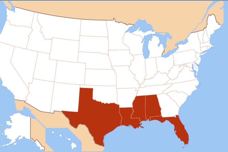
The U.S. Gulf Coast, the theater named in the Independent bulletin, is a low, densely built, energy-intensive shoreline. In operational weather use it means Texas, Louisiana, Mississippi, Alabama, and the Florida Panhandle. Houston and Galveston sit on a ship channel that handles a large share of U.S. petrochemical traffic. New Orleans sits in a bowl behind levees, pumps, and the Mississippi River protection system rebuilt after 2005. Mobile, Gulfport, Biloxi, Pensacola, and Panama City are smaller and equally exposed. Barrier islands take the first surge. Grand Isle in Louisiana, Dauphin Island in Alabama, and the Bolivar Peninsula in Texas have been overwashed in prior storms. Offshore platforms and Port Fourchon feed a large fraction of Gulf oil and gas ashore. A hurricane warning there is an energy-market event as well as a public-safety event.
Storm surge, not the Saffir-Simpson category number, is the primary killer in Gulf landfalls. Category 1 hurricanes carry sustained winds of 74 to 95 mph. Category 2 storms carry 96 to 110 mph. Category 3 storms carry 111 to 129 mph. Category 4 storms carry 130 to 156 mph. Category 5 storms carry 157 mph or higher. Harvey in 2017 came ashore as a Category 4 near Rockport, Texasthen stalled and dropped more than 60 inches of rain on parts of southeastern Texas. Katrina in August 2005 overwhelmed New Orleans-area levees and killed about 1,800 people. Ida in 2021 hit Port Fourchon as a high-end Category 4, knocked out transmission into New Orleans, then caused deadly flooding in the Northeast. Those storms are the memory against which Gulf residents judge any new name on the map. Wikipedia’s entry on Hurricane Isaias records the 2020 track, the North Carolina landfall, and the tornado swarm in one place. The National Hurricane Center remains the primary source for the live 2026 cyclone.
Watches, warnings, and the aid sequence
Watches and warnings are geographic polygons, not county-by-county press releases. A tropical storm watch or hurricane watch goes up 48 hours before possible conditions. A warning goes up 36 hours before expected conditions. Local emergency management then converts those polygons into zone-by-zone go or stay orders. In Louisiana the coastal parishes use a staged evacuation, starting with the outside barrier and working inland. Texas uses county-level reverse-lane plans on Interstate 37, Interstate 10, and Interstate 45 when a Houston or Corpus Christi strike is in play. Alabama and Mississippi lean on Interstate 10 and inland sheltering in Hattiesburg, Jackson, and Montgomery. Florida’s Panhandle uses a mix of Interstate 10 westbound and inland routes toward Dothan and Tallahassee. None of those plans work if the order comes after the surge arrives.
Federal help follows a sequence. Local declaration, then state, then a gubernatorial request to the president for an emergency or a major disaster. FEMA, under the Stafford Act, can fund debris removal, housing, public infrastructure, and hazard mitigation. Flood coverage is a separate National Flood Insurance Program product. Wind is generally a private-market homeowners item, with state wind pools in Texas, Louisiana, Mississippi, Alabama, and Florida filling gaps the admitted market will not write. Deductibles on Gulf wind policies are often a percentage of insured value, not a flat dollar figure. That structure matters to households already carrying higher borrowing costs.
Related: Growing Your Audience in Springfield, Missouri: Organic Reach vs. Paid Ads
ByteSize Network will update this file when a landfall point, a sustained-wind figure, or an official casualty count is confirmed by the National Hurricane Center, a state emergency office, or a second major wire. Until then the confirmed fact is the one The Independent put on its bulletin. Counties on the Gulf Coast have declared a state of emergency for Hurricane Isaias. Local orders remain the binding instruction. Emergency managers treat surge zones as lethal. A higher category number is not required before a low-lying parish or county is evacuated.
Frequently asked questions
What does a county state of emergency do during a hurricane?
A local emergency declaration lets a county or parish waive ordinary purchasing rules, set curfews, open shelters, and ask the state for help. A governor's declaration then opens National Guard duty and a path to FEMA aid under the Stafford Act.
Has the name Isaias been used for an Atlantic hurricane before?
Yes. Hurricane Isaias in 2020 made landfall near Ocean Isle Beach, North Carolina, as a Category 1 storm, caused about $4.8 billion in U.S. damage, and was not retired by the World Meteorological Organization.
Which states sit on the U.S. Gulf Coast in operational weather use?
Operational weather desks treat the U.S. Gulf Coast as Texas, Louisiana, Mississippi, Alabama, and the Florida Panhandle. Exact watches, warnings, and evacuation zones are set by the National Hurricane Center and by each state.
Where are official forecasts for Hurricane Isaias issued?
The National Hurricane Center in Miami issues the tropical cyclone advisories, watches, and warnings. State emergency management agencies convert those products into evacuation orders.
Sponsored · Buying, selling or investing in property? JL Group works with owners and investors in Springfield, Missouri and beyond. jlgroup.online · Advertise on ByteSize Network