
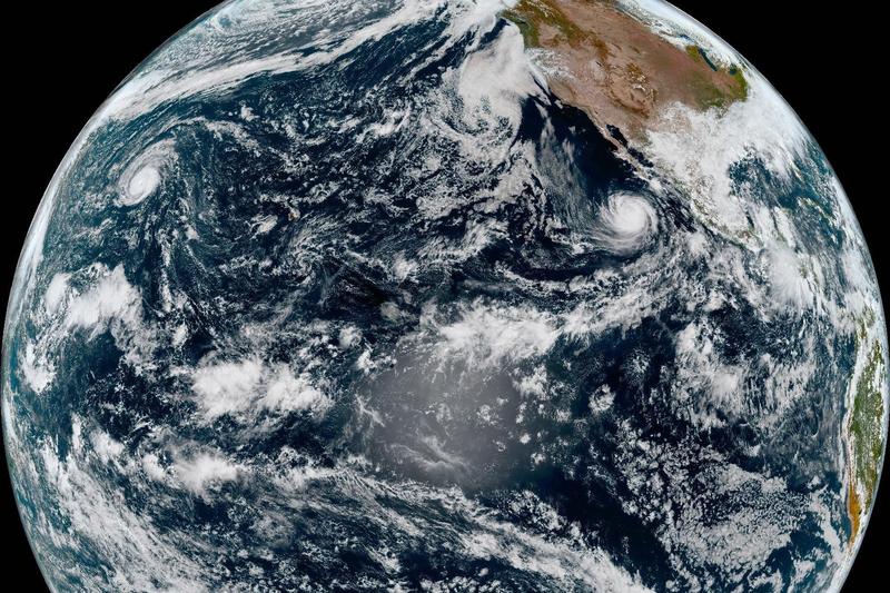
Typhoon Nolo Forms After Crossing Dateline
Hurricane Nolo officially became Typhoon Nolo on Sunday, October 4, 2026, after crossing the International Dateline. The storm is currently situated approximately 395 miles (640 kilometers) west-southwest of Lisianski Island, tracking westward at 17 mph (28 kph). It maintains maximum sustained winds of 115 mph (185 kph), according to the latest advisories. Forecasters from the U.S. National Hurricane Center indicate that Typhoon Nolo is not expected to pose a threat to any landmasses through Friday. This development follows Nolo’s earlier trajectory, where it skirted Hawaii as a hurricane a week prior, weakened to a tropical storm, and then regained hurricane strength on Friday.
Official Statements and Forecasts
John Cangialosi, a senior hurricane specialist with the U.S. National Hurricane Center, confirmed the storm’s status change. “Nolo’s transition to a typhoon is a standard meteorological classification change once it crosses the International Dateline,” Cangialosi stated. “While it maintains significant strength, current projections show it moving away from populated areas for the foreseeable future.” The National Hurricane Center continues to monitor the storm’s path and intensity. Another significant weather event, Hurricane Rachel, is also progressing westward in the Pacific, away from Mexico, generating dangerous waves and swells along the coast of west-central Mexico and the Baja California Peninsulaas reported by The Independent.
Background on Pacific Storm Systems
The classification of tropical cyclones, such as hurricanes and typhoons, depends on their geographical location. Storms in the Atlantic and Northeast Pacific are termed hurricanes, while those in the Northwest Pacific are called typhoons. Both are essentially the same phenomenon, characterized by rotating organized systems of clouds and thunderstorms that originate over tropical or subtropical waters and have closed low-level circulation. The International Dateline serves as the arbitrary demarcation line for this naming convention. The Pacific Ocean is known for generating some of the most powerful tropical cyclones globally, with seasons typically running from May to November in the eastern Pacific and year-round, with a peak from July to November, in the western Pacific.
The formation and intensification of these storms are influenced by warm ocean waters, low wind shear, and atmospheric instability. Monitoring these systems is crucial for coastal communities, even when direct land impact is not immediately forecast, due to the potential for indirect effects like ocean swells and rip currents. The U.S. National Hurricane Center, based in Miami, Florida, is a primary source for forecasts and warnings regarding tropical weather systems in the Atlantic and eastern Pacific basins. Their work involves extensive satellite monitoring, reconnaissance flights, and sophisticated computer modeling to predict storm behavior. For more information on hurricane preparedness and safety, the National Hurricane Center website provides comprehensive resources.
Historical data shows that tropical cyclones can undergo rapid intensification, making continuous monitoring essential. The 2026 hurricane season has seen several notable storms, and the shift of Nolo to a typhoon highlights the dynamic nature of global weather patterns. While this particular storm is not currently threatening land, the presence of multiple active systems, including Hurricane Rachel, shows the ongoing need for vigilance in regions susceptible to tropical cyclone activity. Previous ByteSize Network coverage has detailed the impact of natural disasters, such as the mass shooting at a Georgia homecoming partywhich, while unrelated to weather, demonstrates the public impact of sudden, unforeseen events. The scientific community continues to study these phenomena to improve forecasting accuracy and mitigate potential risks.
Frequently asked questions
What is the current status of Typhoon Nolo?
As of Sunday, October 4, 2026, Typhoon Nolo is located approximately 395 miles (640 kilometers) west-southwest of Lisianski Island, moving west at 17 mph (28 kph) with maximum sustained winds of 115 mph (185 kph).
Related: Yellowstone Spinoff ‘Marshals’ Returns for Season 2 – How to Watch Live
Why did Hurricane Nolo become Typhoon Nolo?
Hurricane Nolo transitioned into Typhoon Nolo because it crossed the International Dateline. Tropical cyclones are called hurricanes in the Atlantic and Northeast Pacific, and typhoons in the Northwest Pacific.
Is Typhoon Nolo expected to make landfall?
Forecasters do not expect Typhoon Nolo to threaten any land through Friday, October 9, 2026.
Who is John Cangialosi?
John Cangialosi is a senior hurricane specialist with the U.S. National Hurricane Center.
Sponsored · Put your business in front of ByteSize Network's readers, with every click measured. See advertising packages · Advertise on ByteSize Network