
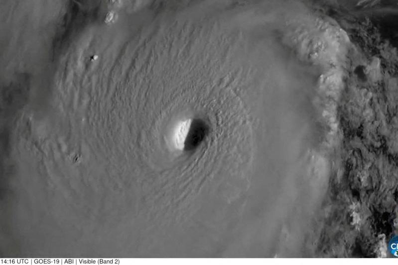
Hurricane Polo, a Category 3 storm, is currently impacting Mexico, with its center expected to reach the coast of Baja California Sur late Monday afternoon or early Monday evening, September 28, 2026. The hurricane carries maximum sustained winds of 115 mph (185 km/h). Following its initial landfall, the storm is projected to move into southern Sonora late Monday night or early Tuesday morning, according to the New York Post. Hurricane warnings are in effect for parts of Baja California Sur’s coasts and Mexico’s mainland from Bahia Kino to Huatabampitosignaling a significant threat to coastal communities.
The storm is anticipated to deliver substantial rainfall, with 6 to 12 inches across parts of Baja California Sur and 4 to 6 inches in parts of Sonora. Other areas of Mexico could see up to 8 inches of rain. This heavy precipitation carries a high risk of life-threatening flooding and mudslides. The remnants of Hurricane Polo are also expected to bring a significant flood threat to the southwestern and central United States from Monday through Friday.
Official Responses and Preparedness Efforts
Mexican authorities have taken proactive measures in anticipation of Hurricane Polo’s arrival. Evacuation orders have been issued for vulnerable areas, and numerous shelters have been opened to provide safe refuge for residents. Military troops have been deployed to regions expected to be most affected by the storm, aiding in preparedness and response efforts. These actions show the gravity of the situation and the commitment to minimizing potential harm to the population.
The National Hurricane Center has been issuing regular updates, advising residents in the path of the storm to remain vigilant and follow local emergency instructions. The coordination between various government agencies aims to ensure a swift and effective response to the unfolding natural disaster. For more information on hurricane preparedness, the National Hurricane Center provides comprehensive guidelines.
Hurricane Polo’s Trajectory and Historical Context
Hurricane Polo previously intensified to a Category 5 storm, reaching maximum sustained winds of 180 mph (290 kph) at one point in its trajectory. While it has since weakened to a Category 3, its prior strength highlights the dynamic and dangerous nature of tropical cyclones. The storm’s path through the Pacific Ocean has been closely monitored by meteorologists and emergency services across North America.
Related: New Jersey Bait and Tackle Shop Inundated by Nor’easter Flooding
The region of Baja California Sur, a Mexican state on the Baja California Peninsula, is no stranger to hurricane activity. Its geographical location makes it susceptible to Pacific hurricanes, particularly during the late summer and early autumn months. Coastal communities often face challenges related to storm surges, high winds, and heavy rainfall, necessitating robust infrastructure and emergency planning. The state’s economy, heavily reliant on tourism and fishing, can experience significant disruptions from such events.
Sonora, a larger Mexican state bordering the United States, also faces considerable risks from tropical systems that move inland. The mountainous terrain in parts of Sonora can exacerbate the threat of flash floods and mudslides, even from storms that have weakened over land. The agricultural sector in Sonora is particularly vulnerable to heavy rainfall and flooding, which can damage crops and infrastructure. The current forecast for Hurricane Polo indicates a direct impact on both these states, requiring sustained vigilance and response efforts from local and national authorities.
Sponsored · Put your business in front of ByteSize Network's readers, with every click measured. See advertising packages · Advertise on ByteSize Network